

Introduction to Saha
Vision Saha, Wellcome to Saha-gu Office
Introduction to Saha
Location/Natural Environment
Location/Natural Environment
Population and Area
- Area: 40.94㎢ (5.4% of the Busan area and the 5th largest of the 16 autonomous districts. City planning zone occupies 73.28㎢.)
- Population: 364,620 persons from 127,264 families as of July 30th, 2007 (Male: 182,509, Female: 182,111)
Location
| Address of Gu-Office | Direction | Address | Location | Maximum Distance | |
|---|---|---|---|---|---|
| East Longitude | North Latitude | ||||
| 317-16, Dangni-dong, Saha-gu, Busan Metropolitan City |
Eastern End | San 99-1 Gamcheon-dong | 129˚ 00′48.9″ | 35˚ 05′16.5″ | East-West~7.6㎞ South-North~ 11.6㎞ |
| Western End | 1155 Hadan-dong | 128˚ 56′03.0″ | 35˚ 06′31.6″ | ||
| Southern End | San 149 Dadae-dong | 128˚ 58′00.0″ | 34˚ 52′50.0″ | ||
| Northern End | 902 Hadan-dong | 128˚ 57′34.5″ | 35˚ 08′05.0″ | ||
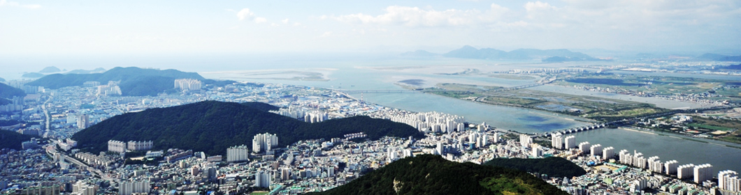
Saha, located in the southwestern part of Busan, is divided from Seo-gu to the east by Mt. Janggun, Mt. Cheonma, Mt. Ami and Mt. Siyak, from Gangseo-gu to the west, by the Nakdong River, from Sasang-gu to the north by the western slope of Mt. Gudeok and the line of Mt. Seunghak from the South Sea to the south, thus occupying the center of west Busan.
Saha is a fault zone mainly composed of faulted mountains, valleys and coasts. The Goejeong River, a tributary of the Nakdong River, originating at Mt. Siyak, once started from the SSari Valley, surrounded Goejeong-dong in a semicircle, flowed to Dang-ri, where it merged with the Dangri River flowing from Mt. Seunghak, passed Hadan and finally flowed into the Nakdong River. However, at present, only a part of the river remains at the estuary of the Nakdong River due to the construction of roads being built to ease traffic congestion.
Gamcheon Bay , between Janggun Peninsula , the Mt. Cheonma range and Dusong Peninsula , and the mountain range at the riverside of Nakdong River once consisted of rocky coasts, but it has now been reclaimed as a part of the Gamcheon Port Development Project to transform the area into an exclusive port of shipment. Also, Busan International Fish Market will be open to become the best international fish market in East Asia .
Jangnim is a narrow valley plain eroded by the Jangnim River and the area between Jangnim and Sinpyeong-dong consists of alluvial plain due to the washed-out soil from Nakdong River. Following the construction of a dyke, stretching from Sinpyeong-dong to Jangnim-dong, in 1939, there were more people working in agriculture than in fishery. However, the area was transformed into the industrial center of Busan with the building of Sinpyeong-Jangnim Industrial Complex and other big and small factories. Large apartment developments and distribution complexes are moving into the surrounding areas, all of which contribute to the prosperous future of Jangnim.
Dadae-hang, stretching from the western Dusong Peninsula to Molundae, is used as a fishing port. It was once used as a beach for swimming because it has shallow water and a sandy beach stretching for about 500m to the west, but it lost its function as a beach, as a dock was built for raw fish restaurants and anglers.
Dadae Beach, a wide sand beach on the western side of the Nakdong River used to be a popular beach visited by many people during summer holidays, but as Gangbyeon-daero was paved and large apartment developments were built in Dadae 5-jigu, it has now become more of a nature-learning center attracting many family visitors. It is also equipped with a variety of accommodations, such as camping spots and parking lots, and many Koreans visit the place to take a good rest.
To the south, there is Jwi Island and Molundae, a steep, rocky coast where camellias prosper. It was one of the places of battle when the Japanese Invasion of Korea took place in 1592.
Many tributaries flow into Nakdong River, which stretches over 700ri (275km) and borders Myeongji-dong, Gangseo-gu. On the lower part of the Nakdong River, a sand beach has developed along with river delta due to the washed out sediment. Only small boats can enter the river since the width of the estuary is about 2-3km, and the depth of water is only about 1-2m.
Since Eulsuk Island, a river delta at the mouth of the river, provides the ideal living environment for plants and animals along with its broad field of reeds, as many as 12 different plant families and 21 species are living on the island and subtropical plants are concentrated on Molundae and Dusong Peninsula coast.
Moreover, the lower Nakdong River, natural monument No. 179, is famous as the greatest habitat for seasonal birds in the East and a number of seasonal birds migrate to feed on the abundant fish and shellfish, including marsh clams and sea strings. It is a spectacular and rare scene to witness various seasonal birds visit this place, build a habitat and leave the place soaring up the sky. The Nakdong River Eco Center was established in 2007 to help the understanding and learning of the Nakdong River estuary ecosystem.
The Saha district belongs to the climate zone of temperate periodic wind and shows a relatively small difference in temperature between summer and winter, influenced by coastal climate. In spring, the weather is often good, influenced by migratory anticyclones, but it also often rains due to the frequent passage of depressions, which are generated near the Yangtze River.
In summer, the weather shows high temperature and humidity, influenced by the seasonal rain fronts, which are formed between the anticyclones of the North Pacific and the Okhotsk Sea and then by the North Pacific anticyclones. In particular, as it is located in the corner of typhoon movements, Saha is also directly or indirectly influenced by typhoons.
In autumn, the weather is often fine, influenced by migratory anticyclones. In winter, the weather continues to be cold and dry along with northwestern periodic winds, influenced by continental high pressure, but mild compared to other regions, influenced by the coastal climate.

TEL +82-51-220-4000 FAX +82-51-220-4444
COPYRIGHT (C)2008, SaHa-gu, All rights reserved.